Showcase: Reproducible Science in Action
This page showcases real-world outcomes created with Carto-Lab Docker. It's a demonstration of our core RDM philosophy: to provide an infrastructure that enables the creation and sharing of transparent, reproducible scientific knowledge.
The examples below are grouped into two key areas: Training & Education, where CLD lowers the barrier to entry for students and researchers, and Peer-Reviewed Publications, where CLD is used to produce FAIR supplementary materials that accompany scientific papers.
Training & Education
These materials use Carto-Lab Docker to provide hands-on, interactive learning experiences that can be run directly in a browser.
-
Exploring Spatial and Biodiversity Data with Python and JupyterLab This comprehensive Jupyter Book was co-authored by multiple contributors using Carto-Lab Docker's collaborative features. It serves as the official training material for the IOER FDZ and NFDI4Biodiversity, teaching the entire research workflow from data acquisition to final publication.
-
Mobile Cartography Workshops (TU Dresden) This annual workshop series uses Carto-Lab Docker to provide students with a ready-to-use environment for spatial data visualization. It allows them to start experimenting with complex cartographic techniques immediately, without any local software installation.
Peer-Reviewed Publications
A core goal of Carto-Lab Docker is to facilitate the creation of transparent and fully reproducible supplementary materials for scientific publications. The notebooks linked below are not just code files; they are complete, static HTML outputs that combine code, narrative, and interactive visualizations, generated via our integrated publication workflow.
-
Dunkel, A., & Burghardt, D. (2024). Assessing Perceived Landscape Change from Opportunistic Spatiotemporal Occurrence Data. Land, 13(7), 1091. DOI
View Supplementary Notebooks (10)
- S1 Jupyter Notebook: 01_mass_invasion.html
- S2 Jupyter Notebook: 02_reddit_api.html
- S3 Jupyter Notebook: 03_reddit_pmaw.html
- S4 Jupyter Notebook: 04_reddit_privacy.html
- S5 Jupyter Notebook: 05_reddit_vis.html
- S6 Jupyter Notebook: 06_cherry_blossoms.html
- S7 Jupyter Notebook: 07_hotspots.html
- S8 Jupyter Notebook: 08_milvus_conversion.html
- S9 Jupyter Notebook: 09_milvus_maps.html
- S10 Jupyter Notebook: 10_milvus_chi.html
-
Dunkel, A., Burghardt, D., & Gugulica, M. (2024). Generative Text-to-Image Diffusion for Automated Map Production Based on Geosocial Media Data. KN - Journal of Cartography and Geographic Information. DOI
View Supplementary Notebooks (3)
- Notebook 1: Data preparation, spatial tag clustering (Tagmaps)
- Notebook 2: Generative AI parameters & tests
- Notebook 3: Map generation
-
Dunkel, A., Hartmann, M. C., et al. (2023). From sunrise to sunset: Exploring landscape preference through global reactions to ephemeral events captured in georeferenced social media. PLOS ONE, 18(2), e0280423. DOI
View Supplementary Notebooks (9)
-
Dunkel, A., Löchner, M., & Burghardt, D. (2020). Privacy-Aware Visualization of Volunteered Geographic Information (VGI) to Analyze Spatial Activity. ISPRS International Journal of Geo-Information, 9(10), 607. DOI
View Supplementary Notebooks (4)
Conference Contributions
- Poster: IOER RDC Carto-Lab Docker - An RDM Infrastructure for Transparent, Open, and Reproducible Spatial Data Science
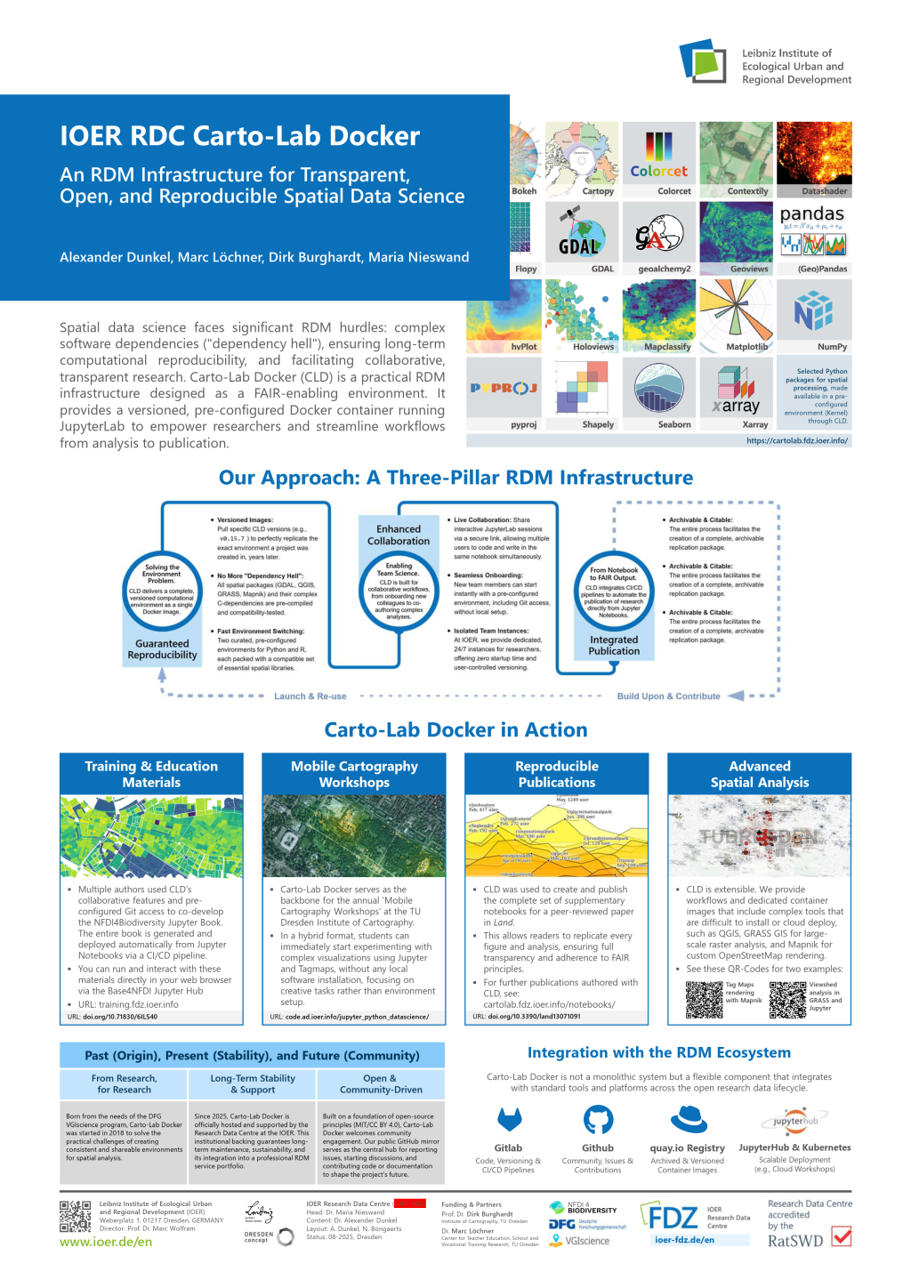
This poster was presented at the 2nd Conference on Research Data Infrastructure (CoRDI 2025) in Aachen, Germany. It provides a comprehensive visual summary of the Carto-Lab Docker RDM philosophy, its three-pillar architecture, and real-world use cases.
Citation:
Dunkel, A., Burghardt, D., Löchner, M., & Nieswand, M. (2025). IOER Carto-Lab Docker An RDM Infrastructure for Transparent, Open, and Reproducible Spatial Data Science (v1.0.0). 2nd Conference on Research Data Infrastructure 2025 (CoRDI), RWTH Aachen University. Zenodo. https://doi.org/10.5281/zenodo.17083789